Livelihoods, Wellbeing and the Risk to Life During Volcanic Eruptions
 Jenni Barclay1*
  Roger Few2
  M. Teresa Armijos2
  Jeremy C. Phillips3
  David M. Pyle4
  Anna Hicks5,6
  Sarah K. Brown3 Richard E. A. Robertson6
- 1School of Environmental Sciences, University of East Anglia, Norwich, United Kingdom
- 2School of International Development, University of East Anglia, Norwich, United Kingdom
- 3School of Earth Sciences, University of Bristol, Bristol, United Kingdom
- 4Department of Earth Sciences, University of Oxford, Oxford, United Kingdom
- 5British Geological Survey, Lyell Centre, Nottingham, United Kingdom
- 6Seismic Research Centre, University of the West Indies, St. Augustine, Trinidad and Tobago
A forensic analysis of fatalities and displacements from recent volcanic eruptions (1986–2015) provides insights into factors that influence actions to protect life in high-risk environments. Unlike many other geophysical hazard events, volcanic eruptions may be prolonged, and of variable intensity. This is reflected in patterns of volcanic fatalities. A global survey reveals that 63% of primary volcanic deaths occur after the first week of activity, with >44% of these deaths associated with citizens returning to an established high-hazard zone. Evacuations during volcanic eruptions are protracted and this allows time for competing pressures to arise. Examination of detailed data from three volcanic crises (La Soufriere, St Vincent and the Grenadines, Soufrière Hills, Montserrat and Tungurahua, Ecuador) suggests that the need to preserve livelihoods plays a strong role in protecting life. A dynamic, associated with pull (e.g., protecting assets, place attachment) and push factors (e.g., poor shelter conditions), can draw evacuees to return during high-risk periods. Similar considerations can restrain people with previous experience of volcanic hazards and displacement, from evacuating. Our global analysis shows that these pressures, when coupled with forecasting uncertainties and the rapid landscape change associated with volcanic eruptions, mean that the physical and social vulnerability of populations change significantly during the course of an eruption. Ongoing risk to life is shaped by hazard experience and action; timescales of hazard escalation and their relationship to warning and action; and the timescales over which evacuation conditions are tolerable to livelihood and asset preservation, and mental and physical wellbeing in shelters.
Introduction
Globally some 800 million people live within 100 km of the world’s 1431 active volcanoes (Brown et al., 2015); in developing countries alone some 722 million are exposed to volcanic hazards (Worldbank Voices, 2017). Violent volcanic disasters that capture the headlines – conspicuous mass mortality events like those at Mount Pelée (Martinique, 1902; Tanguy, 1994) or Nevado Del Ruiz (Colombia, 1985; Voight, 1990) – are comparatively rare, and are perhaps best viewed as extreme end-members of the spectrum of consequences of volcanic activity and its attendant risks. Most recorded eruptions have a duration of between 1 and 6 months (Siebert et al., 2010), but the variance in timespan can extend from individual pulses of activity that sometimes last less than a few minutes (e.g., Tongariro, New Zealand, Scott and Potter, 2014) to activity ongoing for decades (e.g., Soufrière Hills, Montserrat, Wadge et al., 2014) or even centuries (e.g., Kilauea, Hawai’i, Babb et al., 2011). Landscape and infrastructure devastation resulting from volcanic activity can be locally complete (e.g., Merapi, Indonesia, Mei et al., 2013; Plymouth, Montserrat, Loughlin et al., 2002), or partial (within the footprint of tephra fallout, for example, Gudmundsson et al., 2010). Larger volcanic events are capable of global disruption through the injection of ash and sulfate into the upper atmosphere (Oppenheimer, 2003), but volcanic risk on the ground can extend well beyond the reach of newly erupted materials, for example via hazards from re-mobilization of deposited material (lahars, Scott, 1988) and the inherent instability of volcanic edifices (ranging from small landslides to sector collapse; van Wyk de Vries et al., 2000; Donnadieu et al., 2001).
Recent analyses of volcanic fatalities and risk (Auker et al., 2013; Brown et al., 2017) demonstrate that the annualized rate of volcanic fatalities has declined in the last few decades, perhaps indicating the inherent value of improved monitoring, hazard assessment, awareness and communication processes (Brown et al., 2017). However, the conditions that turn hazardous activity into a volcanic disaster are also a construction of pre-existing social circumstances, limited capacities and inadequate responses, even when good monitoring systems are in place (Andreastuti et al., 2018). Given the relatively protracted timescales of volcanic eruptions and the inherent uncertainty in forecasting eruption onset and impacts, interactions between the physical and social dimensions of risk during an unfolding eruptive event can be fundamental in creating or prolonging disaster (Hicks and Few, 2015; Few et al., 2017). Thus, a lack of knowledge of these interactions may reduce capacity to manage ongoing risk and contribute to the loss that continues to be experienced during volcanic eruptions.
We seek to understand the interactions that contribute to volcanic risk during eruptions, where risk is considered to be the interaction of hazard and vulnerability. Vulnerability is to a large extent a socially generated condition and is shaped differentially both by physical and social structures, and by aspects of human agency (Few et al., 2017). So, in the context of long-lived emergencies the cumulative outcomes on vulnerability can be viewed via impacts to wellbeing and access to livelihood security (Wisner et al., 2004; Kelman and Mather, 2008), and this is how we have framed the social outcomes from eruptive activity in this paper.
We begin with a global analysis of the factors behind loss of life during recent ‘fatal’ eruptions, and consider the extent to which factors that influence loss of life also reflect other losses (economic, social and cultural) experienced during volcanic eruptions. The role that acting to preserve a way of life - whether through economic necessity or personal preference - plays in increasing personal risk is often noted for individual cases (e.g., Loughlin et al., 2002; Mei et al., 2013) but, to date, has not been subjected to a global analysis which we report here. We then consider evidence from three volcanic eruptions to understand in more detail the interactions between physical and social drivers of risk, the extent to which these changed during the course of each volcanic emergency, and to what extent the impacts are socially differentiated.
We argue that the new insights this produces can be used to inform adaptations and coping strategies before and during volcanic eruptions, with the aim of improving societal resilience to volcanic risk.
Materials and Methods
Lethal Volcanic Events
We began by recording all fatalities beginning with the Smithsonian Institution Global Volcanism Program reporting on fatal events, and the databases of Witham (2005) and Brown et al. (2017) for the time period 1985–2015. Focusing on those events where primary volcanic activity resulted in five or more fatalities we then interrogated the secondary data (contemporary news reports, reporting from humanitarian organizations) and peer-reviewed literature to understand the context in which these fatalities occurred. We focused on five or more fatalities to exclude a higher proportion of events where the cause of death or the occurrence of deaths were more ambiguous or less well documented. Multiple documentary sources become more frequent as fatality numbers rise. This also tended to exclude events where the fatality has occurred as a result of a freak accident rather than a more usual eruptive episode. While incidents with five or more fatalities are better reported there are still discrepancies, even between online databases. We used Brown et al. (2017) as our primary information source and triangulated our data with that and their sources (where they differed). Where a discrepancy existed we cross-checked and adjusted both databases, making a judgment as to the most likely reported figure, using the criteria developed by Brown et al. (2017).
Qualitative Interview Data and Evacuation Patterns
The three case studies draw on qualitative data from a number of sources. The analyses of drivers for evacuation behavior are synthesized from thematic analysis of interviews and focus groups and supplemented by data from household surveys and the peer reviewed literature that draws on further sources. In Montserrat the synthesis arises from 16 key informant interviews with members of the Montserratian community, government representatives in Montserrat, and the United Kingdom-based Montserratian community. These interviews were preceded by a 2-day forensic workshop with 70 community representatives, government officials, disaster managers, and scientists. In St. Vincent, data were derived from 46 semi-structured interviews, 5 group interviews (41 people in total) and a 400 household survey with residents of the North of the island. In Ecuador we conducted 67 semi structured interviews and a 411 household survey with residents of the slopes of the volcano Tungurahua and local authorities. Synthesized findings from St. Vincent and Ecuador can be found in the reports of Armijos and Few (2015, 2016). The analysis of timelines of evacuation data is largely sourced from locally held reports of evacuation numbers. For St. Vincent these focused on documentary evidence (FCO 63/882, 1971; FCO 63/883, 1971; FCO 44/2030, 1979; FCO 44/2031, 1979) from the United Kingdom National Archives and for Montserrat from data sourced from Hicks and Few (2015), and legislative orders relating to evacuated boundary change.
Displacements and Disruption
Displacements are less well documented than fatalities but our starting point was the Emergency Events Database (EM-DAT) database. These record an annual total of ‘emergencies’ which are triggered by one of: the occurrence of 10 or more fatalities, an ‘affected population’ of more than 100 or the declaration of an emergency by the local government (EM-DAT, 2019). The metrics documented by EM-DAT are ‘affected population’ and ‘homeless,’ so evacuation figures were inferred by cross reference with the contemporaneous reporting to the Smithsonian Institution Global Volcanism Program, and the reporting on ReliefWeb. ReliefWeb is a specialized digitized service of the United Nations Office for Humanitarian Affairs (UN-OCHA). The aim of the ReliefWeb is to provide reliable and timely information in the face of humanitarian emergencies and the information is largely aimed at those who will have to make decisions in the face of those emergencies. Thus, it largely consists of archived ‘situation reports’ from humanitarian organizations and non-governmental agencies, and new organizations designated as trusted information sources by the UN-OCHA. There is a functional bias in the reporting here toward the early phase of emergencies as reports and bulletins are issued as sense is made of the situation and to seek external assistance. In addition to this we also looked at digitally archived newspaper reports and retrospective accounts and research papers. We started by considering all events with reported evacuations but there are often conflicting data and missing reports between these events so we focused on those events that are now well written about in the research literature by interdisciplinary teams seeking to understand the lessons to be learned from these events (see list in the Supplementary Tables). These research based studies tended to involve both survey and qualitative data collected from the affected communities themselves along with locally sourced data on evacuated numbers and calculated or estimated economic losses. We uncovered these research-based analyses by searching using the volcano name and the terms ‘evacuation’ and ‘social’ and ‘impact’ in citation databases. Thus we subsequently focused on the evacuations where we can use these analyses to understand the extent that the dominant drivers identified by us in our study regions are behind actions to evacuate, and/or the defiance of evacuation orders globally. The outcomes of these analyses and summaries of key findings of the complete set of evacuations we surveyed globally are presented in Supplementary Tables S1a,b. A useful expansion of this exercise would be a more complete survey of all reported evacuations (including those not yet explicitly examined in the research-based literature).
Spatial and Temporal Analyses of Specific Evacuation
Our analysis (reported in the discussion and in Figure 4) of the evolution of distance between evacuated and non-evacuated population is compiled from the reports in the SI GVP that indicated length of flows, evacuated zone footprint building locations. This is supplemented by detailed reports of the Montserrat Volcano Observatory, and Unzen Fugendake Eruption Disaster Study Group (2007).
Results
Analyzing Lethal Volcanic Events Since 1985: Examining Risk to Life and Risk to Livelihood
The full social and economic cost of volcanic eruptions is little analyzed but it is clear that the numbers of people impacted by disruption to life and livelihoods, through evacuation or destruction of land and resources, is poorly captured in simple tallies of fatalities. A recent analysis of volcanic fatalities identifies the distance and distribution of fatalities around volcanoes and the activities of the victims at the time of impact (Auker et al., 2013). This characterizes the typical volcanic threat at differing distances from the volcano and the identified groups likely to be exposed to volcanic hazards by their activities. We build on this analysis by considering fatalities in the context of the remaining exposed population, and in particular the relationship with warnings and evacuation processes. An overview of results and the sources used are given in Table 1.
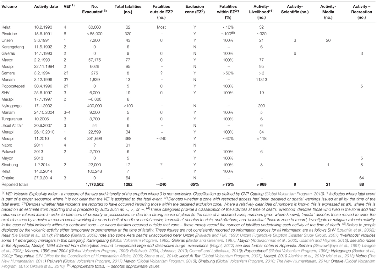
Table 1. Analysis of affected populations for primary volcanic activity with >5 associated fatalities since the mass casualty event of Nevado del Ruiz in 1985.
Between 1986 and 2015 there were 7,043 deaths recorded from direct and indirect volcanic activity worldwide (Brown et al., 2017). We focus here on primary volcanic activity and those events with five or more deaths which account for 1,282 fatalities. These represent 18% of the total, with indirect activity (e.g., floods, lahars, landslides) accounting for 81% and events with five or fewer casualties the remaining 1%. Here, we focus on fatalities by primary activity but acknowledge the importance of multiple-interacting hazards (particularly between volcanic activity and hydro-meteorological hazards). Deaths via primary hazard are the best reported and through them we are able to understand the drivers behind them and consider how this would also apply to the indirect activity. Typically indirect fatalities happen across even longer time-scales than primary fatalities, and so social processes associated with wellbeing and secure livelihoods are even more likely to be a driver for risky behavior. However, warnings and evacuations procedures for some of these hazards may be less well developed, so there may be some limitations to this assumption.
The incidents compiled in Table 1 detail the toll in lives, but at least a further 1.17 million persons were reported to be displaced from their homes at the same moment as the fatalities occurred, with many more impacted during the lifetime of these eruptions. Thus, for these events, fatalities amount to only around 0.01% of the affected populations, many of whom will have had their lives seriously disrupted and their livelihoods jeopardized. Nonetheless, focusing on events with multiple fatalities provides insights into the drivers behind the societal impacts of these events. We argue that the more fully recorded fatalities, and locations and activities of those impacted can serve as indicators of the less well-recorded motivations and pressures on the larger affected populations. This provides us with an initial understanding of how populations expose themselves to volcanic risk and the coincidence of factors that lead to fatalities.
For 35% of these events, there was insufficient time or systems in place for warnings of any type to be called. Where warnings were in place, the pattern of fatal incidents shows a strong association with individuals neglecting those warnings, and instead acting to protect their assets and livelihoods in the face of hazardous volcanic activity. Figure 1 illustrates the relationship between the recorded eruption start date and the occurrence of fatalities: 63% of fatal incidents happen more than one week after the recognized onset of activity. The time-distribution of fatalities relative to onset broadly echoes that of the time-distribution of paroxysmal (or most violent) activity relative to eruption onset, based on all historical events (Siebert et al., 2010).
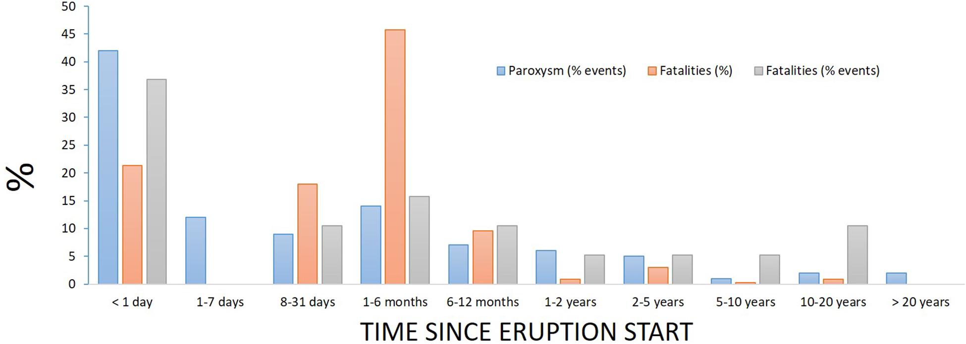
Figure 1. Distribution of the timing of fatalities relative to the start of eruptions. ‘Paroxsyms’ are the occurrence of more violent volcanic activity during a longer sequence of eruption as defined and reported in Siebert et al. (2015). Distribution from 252 events of known duration and intensity in historical record. Fatality timing uses data in Table 1, expressed as % of events and % of overall number of fatalities.
Together these data suggest that a significant portion of deaths could be a consequence of: refusal of some people to evacuate; creeping population return to evacuated zones, to protect assets and preserve livelihoods; or escape from squalid or intolerable temporary accommodation conditions; insufficient mitigation or warning for ‘larger than usual’ events. These constitute a multi-faceted hydra of factors that collectively either push individuals and communities to leave safe areas or pull them back (or to remain in) hazardous zones. Moreover, given the prolonged or intermittently repeating sequences typical of volcanic activity the rate and number of re-entries to threatened areas will be likely be highly dynamic. In the next section we consider the extent to which these factors are revealed in a more detailed data set.
Qualitative Interview Data From Soufriere Hills, Montserrat, La Soufriere, St. Vincent and Tungurahua, Ecuador: Further Revelations on the Push and Pull, Life and Livelihood
To understand the nature and relative importance of these push and pull factors across differing contexts and demographic groups, we now consider details from three case studies, two long-lived and one shorter duration: Soufrière Hills, Montserrat (1995–2000 Phase 1); Tungurahua, Ecuador (1999–2014) and La Soufrière, St. Vincent (1979). We selected these eruptions because we have detailed information on the evacuations over time, supplemented by interviews, survey and focus groups that uncover attitudes, motivations and views from across several demographic groups. Chiefly this involves those who would be or were evacuated in response to heightened, but not necessarily paroxysmal, activity (Armijos and Few, 2015; Hicks and Few, 2015; Wilkinson, 2015; Armijos and Few, 2016; Few et al., 2017). The detailed evacuation pattern for two of these eruptions is illustrated in Figure 2, along with data from another recent evacuation (Merapi, 2010; Mei et al., 2013) to demonstrate that patterns of duration, and variability are not specific to the Caribbean.
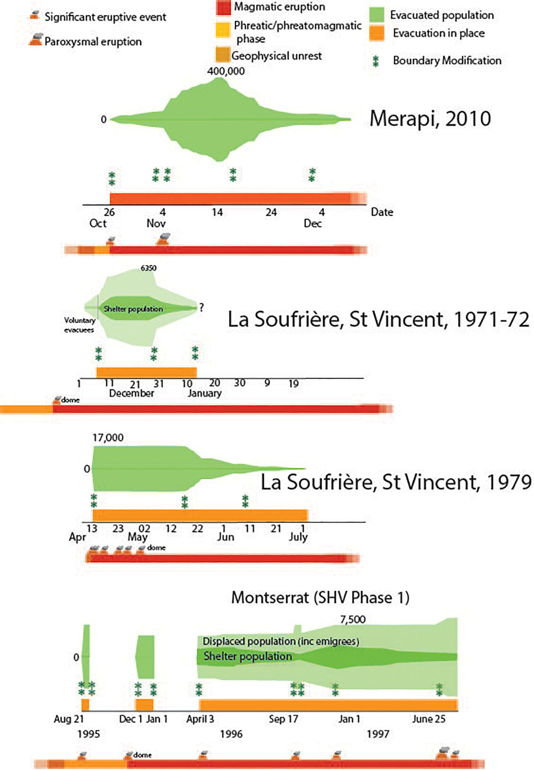
Figure 2. Details of pattern of evacuation and population in shelters for Montserrat, St. Vincent and Java during the eruptions of Soufrière Hills, Soufrière and Merapi respectively. Data on shelter numbers is as follows St. Vincent (1979)-FCO44/2030 and 2031(54) (1971), FCO63/882, 883(55) and 1022, Montserrat Clay et al. (1999). Merapi is from Mei et al. (2013). Fatalities at Montserrat were due to the paroxysmal eruption of 25 June 1997. Fatalities at Merapi were caused both by the rapid-onset eruption (October 26) and the later paroxysm (November 4–5, 2010).
Pull and Push Factors
A detailed examination of timings and evacuation patterns mirrors the bulk data with long duration (>1 week) evacuations through which eruptive behavior varies. In the case of these archetypes, the fatalities (at Merapi and SHV) are both associated with paroxysmal activity that occurred some days (Merapi) or years (SHV) after the start of eruption and the first evacuations (Figure 2). From our interview data, the strongest pull factors for return to high-risk zones at these volcanoes relate to a desire to protect assets and reduce income losses, reinforced by people’s sense of attachment to home. It is important to note that attachment to place can also include the attraction of the traditional way of life, and the wellbeing and sense of purpose that arises in living in close proximity to kin and ancestral lands. Push factors prompting people to leave shelters were associated principally with cases in which shelter provision was poorly organized or under-resourced, resulting in prolonged reduction of wellbeing, health and personal security.
St. Vincent
During the evacuation periods in St. Vincent (Figure 2) many people made occasional visits by day to their properties, both to protect their livestock, crops and homes, but also because these were the places they felt at home, the places with which they identified a sense of wellbeing and normalized social relations, but which they perceived were badly damaged or under threat.
The day that local residents were evacuated from their villages they were instructed to let their animals loose so that they could freely roam and feed. As a result, crop damage by ashfall was exacerbated by foraging livestock. Moreover, large numbers of livestock were lost because of illness, lack of water, and theft. As one evacuee noted:
Well people lost crops, and many people lost their animals from death and from stealing. Most people had let go their animals and people used the opportunity to steal.… That is what people said. But I think other people just killed animals and eat them as well
Woman from Troumaka. 13 August 2014
As Cato (1979) noted, theft of property, including burglary of shops was reported as widespread. This was also highlighted during the interviews we conducted with local residents:
People who were outside the village would go to your house once the house is closed and steal away your things
Man from Rose Bank, 1 August 2014
At the same time the general conditions and organization of shelters on the island were often difficult. In 1979, about two thirds of the evacuees stayed in 59 designated shelters, and the remaining one third at family or friend’s homes (Gueri et al., 1982). During up to 6 months of stay in the shelters the most common distresses people faced were: lack of space, lack of privacy, children’s illnesses and weak logistical organization.
I think because it was the first experience I don’t think the camps were well organized. There was a lot of chaos. The priority should have been on the people who evacuated from outside the area. But even people from the area were competing with people in the camps, maybe asking for food. Some camps were well run others were not depending on the individuals.
Man from Petit Bordel, 14’ August 2014
Montserrat
In the case of Montserrat, returns by some people into the exclusion zone proved fatal (Table 1 and Figure 2). For the majority of evacuees, a return home was not an option because of the devastation of settlements, but for those who owned farm plots with standing crops in the hills the pull was substantial. Farmers were seldom able to establish new sites of production during the prolonged evacuation period and, as the food supply situation in the shelters began to deteriorate, it made strong economic sense for them to re-enter the high-risk area to harvest standing crops before they perished.
…“we were seeing guys come in with foot and a half long carrots and we’d say hey, where was this grown and they’d say right up there [the exclusion zone]… the government agreed let us take some money and purchase some of the crops from them so that at least they could harvest and have some income and [for] the people in the shelter at least we could change the diet a little bit and make it a little easier…
(Community Services Employee, September 2012).
The inquest into the 19 fatalities that occurred on 25th June 1997 determined that the failure of British and Montserratian governments to provide land for displaced farmers had contributed to nine of the deaths.
In tandem with the pull factor of standing crops, so the conditions of shelter life became a push factor for people to re-enter the exclusion zone (Loughlin et al., 2002; Hicks and Few, 2015). The authorities struggled to find adequate shelter for evacuees in designated emergency shelters such as schools and churches, erecting tents in the early stages, followed by metal prefabricated structures and timber chalets. Funding for emergency housing was not allocated until July 1997. Clay et al. (1999, p. 34) report that: “The public shelter program was basically successful in providing everyone with immediate shelter, but was unsatisfactory in providing for more extended occupation.” However, most shelter types were used for extended periods of time, amid reports of a general squalor, compounded by hygiene, food supply, mental health and security issues, including incidences of aggression, sexual abuse and rape.
…“Now a church is designed to have a 2 h, at the most, celebration, and you return home. But when you convert that now to a place where folk are living, no partitions, and the restroom facilities were not designed for 60-100 people.”
(Community Services Employee, September, 2012)
The disposal of human waste was a major problem, possibly contributing to the increased levels of gastro-intestinal diseases recorded during the crises.
“The sanitation consisted of pit latrines less than 2 m deep. They were intended to be in use for 2 days. They were, in fact, used for more than 2 years.”
(56, Patullo, 2000, p. 94).
Tungurahua
At Tungurahua, management of the initial evacuation process by Ecuadorean national and local authorities led to a combination of push/pull factors that created a major story of mass protest and return to the environs of the volcano.
After the reactivation of the volcano in September 1999, an evacuation order was applied to all settlements on or close to the slopes of Tungurahua, including the town of Banos de Agua Santa, a major tourism destination. Within three months of the evacuation, strong voices of dissent about the continuing exclusion from their residences were circulating among evacuees, prompted by the pull of lost income and concerns over abandoned property, and the push of inadequate shelter assistance and provision, plus the failure by that time of the eruption to escalate as initially feared. People began to challenge the evacuation order and confront those guarding the exclusion zone in a bid to return, and in January 2000 the authorities lifted restrictions and allowed the return process to begin (Tobin and Whiteford, 2002; Mothes et al., 2015).
Subsequent events at Tungurahua, however, showed a marked change in the public acceptance of evacuation and in people’s cognitive-behavioral relations with the volcano. Detailed analysis of the relationship between evacuations, eruptive behavior and warning and monitoring demonstrates this evolution (Armijos et al., 2017). In August 2006, six people died (Table 1) when returning to protect their assets, after evacuation on that day. Subsequently self-evacuation and the co-creation of an adaptive management system was facilitated by the building of re-settlement homes and further improvements to an informal monitoring network involving scientists and members of the community (Armijos et al., 2017).
Role of Knowledge and Experience
In both St. Vincent and Montserrat people made decisions over time to return to their homes or land in the high-risk zones, but it is the story of Tungurahua’s prolonged eruptive period in which many people have co-existed with intermittent volcanic activity that is most illuminating in terms of how people draw on knowledge and experience in their relation with risk.
After the initial events of 1999, drawing on a mix of scientific advice, training and their own experience and understanding as the eruptive phase unfolded, people began to develop their own knowledge of the volcano’s behavior (Mothes et al., 2015). They began to weigh up for themselves when to evacuate. In a survey of residents, 62% said they have evacuated or are willing to do on a voluntary basis – taking action even before the authorities have called for an evacuation.
Yes we are used to it, and have the experience. Now everyone knows and if they see anything unusual they leave. People leave before they are told to do so […]. When people feel something, you would see the buses in the afternoons full of people going to sleep in Penipe. When they feel something is going to happen they also put their animals closer to their home in safer areas.
Woman from Choglontus, 20, February 2014
Improved monitoring and a network of community-based observers have helped develop this capacity (Stone et al., 2014), but it is important to emphasize that this knowledge is something over which people themselves feel they have ownership. It is theirs as much as it is the scientists and authorities. It empowers people to take responsibility for the decisions they make themselves about their lives and activities. They decide when and why they stay in the high risk zone and make decisions relating to what to do with their animals and crops, depending on the perceived activity level of the volcano.
Two key things are worth pointing out here. First, in developing their knowledge, people learned that they could take action to mitigate the impacts of evacuation (and thereby reduce the pull factors for unsafe return) – including putting their animals in safe locations before leaving the area. Second, this sense of empowerment in large part depended on them having a known and secure shelter option (thereby reducing the push factors), in this case often the resettlement homes provided by the state in neighboring districts (Armijos et al., 2017).
Although people base their decisions on a combination of their experiences and information from authorities/scientists, their interpretations can also be hazardous in themselves, particularly in cases when the volcano activity level rapidly accelerated. This was the case during the February 2014 eruption, which caught most people by surprise and left the community of Cusúa ‘trapped’ between two pyroclastic flows. Put in a different way, experience and knowledge is an important element of people’s ability to cope with long term exposure to volcanic activity of the same magnitude as they have experienced until now (VEI 1-3), but does not necessarily prepare them well for activity of significantly greater magnitude.
In summary, our data reveal that recent fatalities during volcanic eruptions have an association with their longevity and variability. Furthermore these fatalities are a reflection of wider decision-making in response to these eruptions. During comparatively long-lived episodes cumulative push and pull factors generate increasing impetus to return to high risk zones. Pull factors arise from: the need to protect livelihoods and assets (in the context of our case studies often crops and livestock); and attachment to place and community. Push factors relate to poor shelter conditions including: overcrowding and poor sanitation, boredom and mental health issues and inadequate access to food, water and hygiene.
Shared solutions need to be robust to coping with the considerable uncertainties associated with volcanic activity, and aware of the ‘push and pull factors’ associated with reoccupying prohibited land.
Displacements and Disruption: Implications for Actions for Return to Hazardous Zones
To consider the extent to which the push and pull factors from our case studies are context dependent or representative of conditions during volcanic activity we also examined events for which there is a record of displacement as the result of volcanic activity for the same period worldwide. These are synthesized in Figure 3, more detailed data are found in Supplementary Table S1.
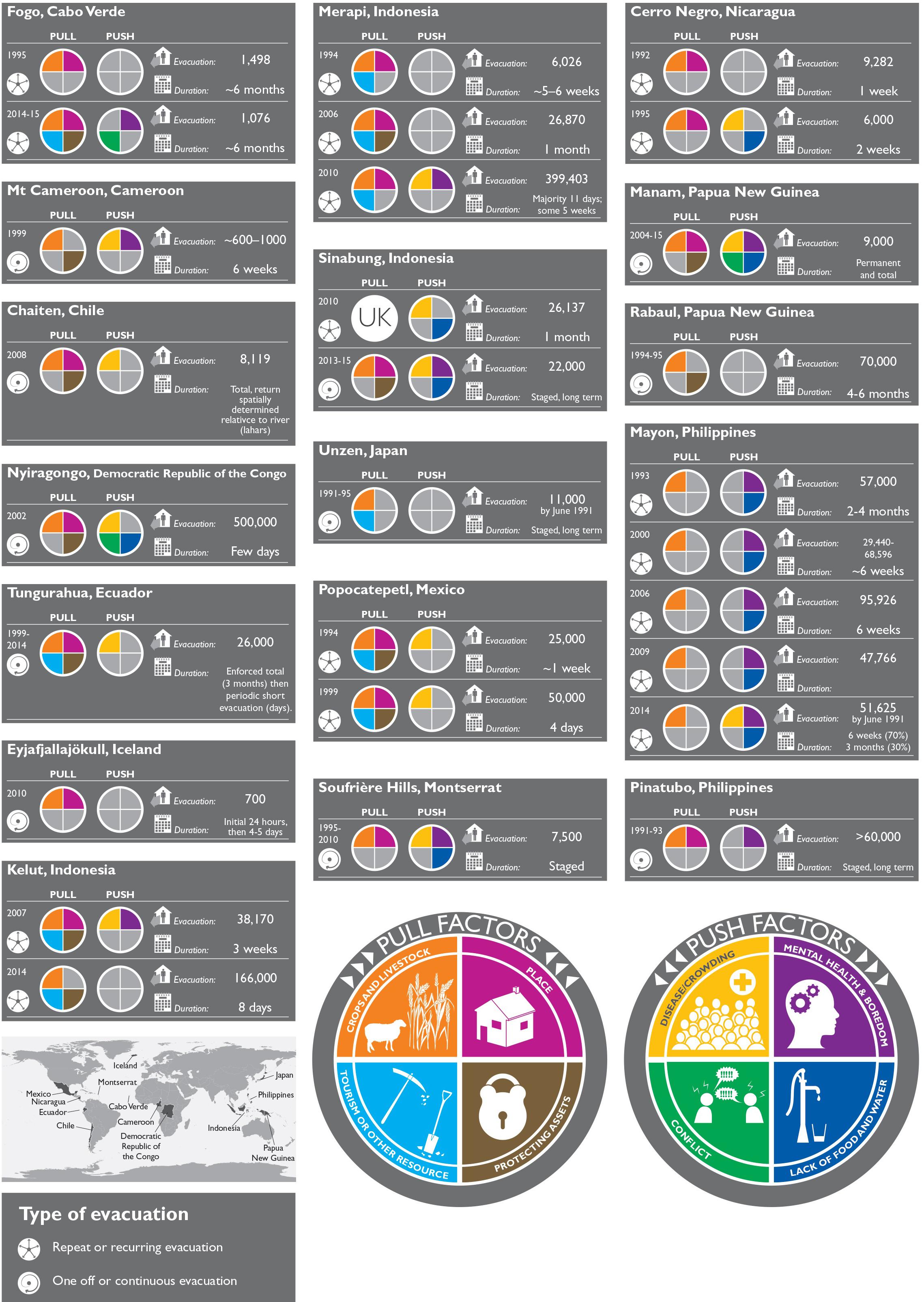
Figure 3. Global comparison of pull–push drivers behind evacuations 1986–2015 where analysis of social drivers behind decision-making is available. Evacuations refers to peak no. of people evacuated, duration is typically median amount, return reporting is often less detailed. Further details are in Supplementary Tables. ‘UK’ in some segments mean ‘unknown’ (no analysis of push or pull drivers). Note here an absence of factors may mean an absence of reporting rather than lack of occurrence where one or two drivers have been reported.
The reporting of evacuation processes is asymmetric: information on numbers displaced tends to be good at the beginning of the process, becoming less detailed as evacuated numbers decline. Often the ‘end date’ for evacuation is not reported, particularly when houses and settlements are permanently destroyed as the result of activity. We have compiled most reliably gathered metrics around evacuation for the period 1985–2015 these were decided on after our synthesis of the research literature. They are listed in the Supplementary Table S1, along with the source references. These include, the duration of the event, the triggering activity for an evacuation, evacuation duration and numbers evacuated (most typically at the evacuation ‘peak,’ the degree of compliance with the evacuation, and the extent to which the push and pull factors we have identified are noted in these global case studies). These numbers are not always reported but represent the most consistent analyses that we were able to glean from the research literature (which was often written with a different purpose than that of our analysis here); further notes on these data and all data sources are provided in the Supplementary Table S1. The locations of our global analyses, identified push and pull factors, peak evacuation numbers and evacuation style and numbers are illustrated in Figure 3.
Collectively, these data underline a key finding from the data on fatalities: there are many more events with a significant impact on livelihoods than fatal events alone. With the caveat that few evacuations last for <24 h, volcanic evacuation data broadly mirrors the distribution of eruption duration and fatalities in Figure 1 with 8 evacuations in each of the 8–31 days and 1–6 month length categories of the Smithsonian dataset (Siebert et al., 2010) from the 22 events documented in Supplementary Table S1a. A significant proportion of eruptions involve permanent relocation or protracted or repeated evacuations (Supplementary Table S1). We have divided the data into ‘recurrent’ eruptions (those volcanoes with discrete evacuation and eruption episodes during the evacuation time interval) and one-off or persistent eruptions (those volcanoes with single, intense but short-lived episodes or longer-lived episodes where social response or eruptive behavior is harder to discretize).
The available data on evacuation numbers and compliance demonstrate that the recorded fatalities in Table 1 only represent a small proportion of the population who are moved from, but then choose to re-enter or remain in hazardous zones. Most analyses report a sometimes significant proportion who do not evacuate at all and a more significant drift back to hazardous zones after 1 or 2 days (Supplementary Table S1). Where an important ‘pull’ is tending to crops or livestock, there can be significant numbers who return to high hazard zones during daylight hours but remain in shelters overnight (e.g., Figure 3 and our data for St Vincent, Tungurahua).
Discussion
The Role of Our Identified Pull and Push Factors in Increasing Risk to Life
The push and pull factors that we identified in our detailed study regions are also prevalent across other volcanic regions, in differing development contexts (Figure 3). Considerable theoretical and empirical effort has been extended worldwide in understanding the disadvantages associated with displacement arising from natural and social risks, particularly in a developing world context (Wisner et al., 2012). Critically, many point to the paradox of risks to livelihood and human security being created by the need to leave the risky environment. In particular, a global analysis of displaced populations resulted in the widely used Impoverishment Risks and Reconstruction (IRR) model (Cernea, 1997; Cernea and Macdowell, 2000). This identifies eight components that could contribute to impoverishment in displaced or resettled populations: (a) landlessness, (b) joblessness, (c) homelessness and (d) marginalization (e) food insecurity (f) increased morbidity (g) loss of access to common property resources and (h) community disarticulation.
In a volcanic context arguably the volcanic activity itself is an agent for (a) and (c) in its own right (Supplementary Tables S1a,b) but one of our key arguments here is that the desire to act against these components of impoverishment, interfere with an otherwise apparently more logical desire to preserve life. Our analyses demonstrate that the loss of community and place (h), and the social and physical resources (g) associated with them has a very strong role to play regardless of degree of economic development.
Similarly anxiety around food security and joblessness is reflected in the desire to work the land and attend to livestock against hazard advice in many settings. It is also implicit in the push to leave shelters that have inadequate resources, provide little personal privacy and are dislocated from normal income-generating opportunities. The majority of the communities in our analyses are rural in nature, with sources of income and livelihood that are physically and socially linked with the land and ‘fixed’ to the place of normal residence. A useful extension of this work would be to consider the extent to which this relationship between livelihood security, wellbeing and risk to life prevails as strongly in an urban context, where livelihoods are less intimately associated with ‘home’ and land. There is considerable evidence that all of these processes act to amplify pre-existing inequalities (Hicks and Few, 2015; Few et al., 2017) and thus contribute to the marginalization of some sectors of communities at risk. Given the protracted nature of volcanic crises important lessons could be transferred between these and crises not associated with the occurrence of natural hazards (war, famine, climate-induced change).
Over the past 30 years livelihood diversification in developing economies has created risk as well as opportunity for communities around volcanoes. This trajectory is most clearly seen for volcanoes with repeat eruptions across this time period. Tourists are drawn to the spectacle of a volcanic landscape (Bachri et al., 2015; Wardhani et al., 2017) and bring with them opportunities to act as their guide or to provide services to the passing traffic. This provides a strong incentive to continue to live and work in high hazard zones. For example, in an analysis of land resource management around Kelud volcano, Wardhani et al. (2017) identify a near doubling of visitors between 2010 and 2014 and highlight the particular draw of a volcanic landscape in the few years immediately succeeding an eruption as a strong incentive to exploit this interest. Tourism was also a strong incentive to re-occupy land on Fogo (de Castro and Martins, 2018) and Merapi (Mei et al., 2016).
The exploitation of mineral resources, and more frequently sand mining also acts as a pull for (at least temporary) re-occupation of high risk areas, and particularly the narrow high risk avenues associated with lahar pathways around volcanoes (De Bélizal et al., 2012). Further, the damage associated with high intensity haulage traffic from larger-scale quarrying operation has also damaged roads, thereby decreasing evacuation efficiency during emergencies (Blake et al., 2015). Where livelihood diversification and increase in asset ownership had occurred, subsequently a greater will was also expressed in interviews to protect those assets in situ (De Bélizal et al., 2011, 2012 and our case studies of St. Vincent). Though there have been studies published that challenge the ‘looting’ myth (Quarantelli, 2001), nonetheless this analysis suggests that asset protection – real or perceived – exerts a strong control on decision-making (e.g., our detailed case studies and e.g., Rabaul, Nyiragongo). The drive to be present to protect against looting reinforces the value of returning for cleaning and maintenance in the face of persistent volcanic activity.
There are also recurrent push factors associated with unsatisfactory shelter conditions and the problems associated with the long-term support of additional populations. Tensions may even arise between the evacuated and host community (e.g., Manam). A less dramatic but nonetheless important push that has been identified is the boredom and lack of purpose (‘ennui’) associated with long days in the shelter with little productive work on which to focus (Christia, 2012; Mei et al., 2016). This acts as an incentive to satisfy curiosity and seek occupation by visiting the evacuated zone, consistent with the ‘joblessness’ issue identified in the IRR model (Cernea and Macdowell, 2000).
The most positive coping strategies seem to have emerged around the ‘pairing of settlements’ in and outside the hazard zone, where physical common ground exists that can be cultivated and used and where social common ground exists or has been created in advance of the evacuation period (Andreastuti et al., 2018, our Tungurahua case study). Indeed, a striking feature of the repeat eruptions in Figure 3 where re-settlement sites have been created is the extent to which these become ‘second homes’ for temporary occupation during higher level emergency, rather than at all times. This is not true homogeneously across any population, but is evident in Mayon, Tungurahua, Manam, Fogo, Merapi and Rabaul (Supplementary Table S1). This is secondary evidence for the strong pull that higher-risk land around the volcano can exert.
Collectively, these data suggest that the need to sustain livelihoods and wellbeing has a strong role to play in decision-making and actions that endanger life during volcanic crises. In the immediacy of a crisis (hours) it is possible to prioritize actions to save life but the evidence presented here suggests that within only a few days, for some sectors of the population, the immediate danger is outweighed by other considerations. Decisions to move back into the higher risk zone, whether permanently or transiently, are not always compatible with the eruptive pattern of the volcano, and fatalities then ensue both directly (Table 1) and as the result of later indirect hazards. Dynamism is not restricted to hazard exposure but also to social and physical vulnerability during and between eruptive episodes. Critical to improving outcomes (in terms of loss of life and implicitly resource and wellbeing) is the development of a shared knowledge of the push and pull factors behind the refusal to leave or the reoccupation of risky territories, in conjunction with developing warning and evacuation mechanisms that are robust to the salient uncertainties of volcanic activity, as exemplified in our Ecuadorean case study. Further, this knowledge must not be a static entity but one that responds both to changing capacity to forecast activity and to changing vulnerabilities of the population at risk.
We will now consider the mechanisms for improving ‘life outcomes’ in the face of volcanic activity suggested by our analysis.
Experience, Knowledge and Warnings ‘In Time’
A striking feature of the global dataset is the extent to which evacuations can be prompted by the occurrence of surface activity (dataset in Supplementary Table S1). Large-scale evacuations rarely occur during pre-eruption unrest, even when volcanoes are well monitored, and there are only few well-documented instances of pre-emptive evacuations happening in the absence of any subsequent eruption. A significant proportion of these events also represent spontaneous evacuation. Like our case study volcanoes, local populations develop a strong experiential knowledge of volcanic behavior at frequently active volcanoes. This is referred to by Bankoff (2001) as a ‘culture of disaster,’ and these informal systems of warning and action demonstrate a solid foundation on which to build; although it typically involves evacuation prompted by the onset of surface activity. The call to integrate this experiential knowledge with scientific warning networks is not new (e.g., Dove and Hudayana, 2008) or unique to volcanic settings.
However, although experience strongly relates to the ‘most likely’ eruptive behavior, our evidence suggests it does not incorporate ‘maximum expected’ behavior or even paroxysmal activity. Further, many volcanic systems are characterized by common low-lying (or orographic) cloud or even intense rainfall which can obstruct lines of sight to early signs of renewed activity, reducing time-scales for action. Significant difficulties (and fatalities) can ensue with even the most aware population when eruptive activity exceeds expectations; and trust eroded when it does not live up to them. For example, at Merapi in 2010 the rapid evacuation of a wider area led to confusion and some fatalities, and had repercussions for the multiple relocation of displaced populations (Mei et al., 2013; Bakkour et al., 2015; Warsini et al., 2015). Similarly, at Tungurahua fatalities ensued when eruptive activity in 2006 surpassed past experience and impacted zones beyond the existing knowledge network (Armijos et al., 2017). Conversely, at Kelud and Karthala significant issues with trust and compliance developed when activity was initially milder than anticipated from previous episodes (Morin and Lavigne, 2009; De Bélizal et al., 2011).
Thus we can point in the direction where critical inroads can be made in achieving effective integration. We need to focus on healing the disjunct between experiential knowledge and that of the impacts of larger scale events. The greater mass of experiential knowledge is usually enjoyed by the communities around any one volcano and the critical mass of knowledge of larger events typically resides with scientists responsible for monitoring risk. Shared risk cultures should find ways to integrate these domains to embrace uncertainty around warning times and eruption size, and enable communities to plan for and respond to larger than normal eruptive episodes. Thus, clearer knowledge of time-scales for evacuation and their relationship to likely timescales around warning would be particularly useful.
A ‘disaster culture’ is not just restricted to knowledge relating to risks but also creates positive bonds with the risky environment, and often the volcano itself (Neumann, 1996; Dove and Hudayana, 2008; Christia, 2012). This connectivity can create shared common identities between communities living there so that ‘place attachment is not solely a relationship between people and their environment (physical attachment), but is enforced through the dynamic relationships of people living in the same environment’ (Warsini et al., 2015). This social and physical attachment is almost always identified as a pull to re-occupy high-hazard zones across settings (referred to as ‘place’ in Figure 3). These relationships to people and land include attachment to traditional practices, spiritual associations with place and the wellbeing associated with living in proximity to kin. Several of our fatal events documented this type of place attachment as the root of some risky decision-making (e.g., Montserrat, Loughlin et al., 2002); and is robust to economic context (see e.g., Unzen, Chaiten and Eyjafjallajökull in Supplementary Table S1).
This also complicates responses to interventions that seek to create livelihood alternatives in lower-risk locations. Members of communities can continue to occupy high hazard zones despite the rehousing of cattle, provision of new grounds for crops or even new settlements (e.g., Merapi, Andreastuti et al., 2017; Tungurahua, Armijos and Few, 2015; Manam, Connell and Lutkehaus, 2016). This suggests risk management strategies need to respond to and embrace the dynamic attachments associated with the high-risk environment as well as the knowledge associated with experience of it.
Many of these studies feature people who remain in the immediate vicinity of volcanoes despite prolonged activity or threat. They represent a particular sub-set of the population who either chose to live with the threat, or are in social circumstances where that choice is not available. Further insights into coping with volcanic disruption could be gained via detailed examination of those who chose to minimize risk via out-migration.
Dynamic Risks in Volcanic Contexts: Timescales of Warning and Threat
Evacuations due to volcanic activity usually last for much longer time periods than those associated with other intensive hazard events, typically from days for hurricanes (Lindell et al., 2011) and days to a few weeks for floods and flash-floods (Haynes et al., 2009). We have already noted that the distribution of fatalities, eruption time-scales, paroxysmal activity and evacuations are broadly consistent: many eruptive episodes can persist for months or even years. The empirical evidence from actual decisions to evacuate, and population ‘drift back’ during eruptive episodes suggests that the practical tolerance of actions to preserve life for significant sectors of the population are of the order of hours and days.
In practice this apparent paradox is dealt with via the use of ‘staged’ evacuations and sectoral management of risk. Where this is practiced or has been developed we have analyzed the relationship between hazard (maximum runout of lava or pyroclastic flows) and risk outcome (nearest occupied settlement or furthest unoccupied house) over time (Figure 4).
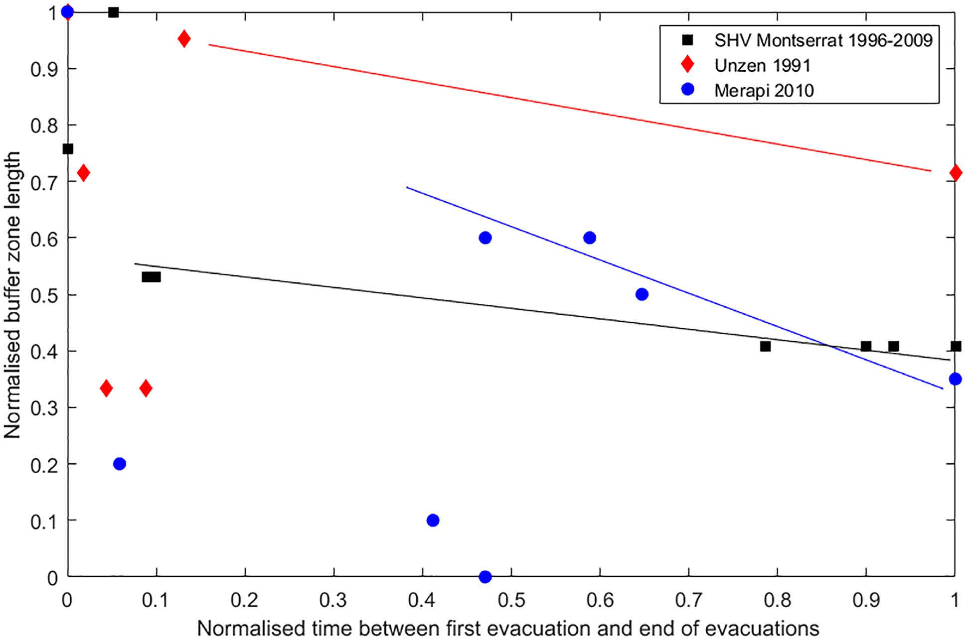
Figure 4. Normalized buffer zone length against normalized duration of eruption for three eruptions that experienced staged evacuations. The normalized buffer zone length is the ratio of the length of the buffer zone (the shortest distance between the active surface flows and a non-evacuated population), and the maximum length of the buffer zone at any point during the eruption. The buffer zone length changes over time with both the volcanic activity and decisions to evacuate and reoccupy different 15 areas. The maximum buffer zone length and duration of the eruptions are 2.1 km and 4 months for Unzen, 6.6 km and 13 years for SHV and 10.0 km and 16 days for Merapi. Normalized data show that trends in buffer zone length changes over eruption duration are similar for eruptions of very different durations.
For the eruptions analyzed, a ‘buffer’ distance tends to emerge, which is typically of a few kilometers, whereby rapid evacuation of a wider population grouping is possible over the time-scale of a few hours. It is notable however, in the earlier stages of eruption, this relationship is less clear and initial response at the most uncertain stage is most sensitive to the local context. This prevails for the longest normalized time in the case of Merapi (which is the shortest actual duration eruption). Nonetheless the emergence of a buffer distance enables communities at risk and managers of risk to cope with increases of activity typical of the ‘likely’ range of activity.
This strategy is highly dependent on the strength of the communication networks for disseminating warnings, and in some settings encourages the meshing of formal and informal warning networks. For example the ‘JalinMerapi’ network (Lavigne et al., 2008; Wulandari et al., 2018) the ‘vigias’ of Tungurahua (Stone et al., 2014; Mothes et al., 2015; Armijos et al., 2017), and the ‘Beidar’ in Sinabung (Wulandari et al., 2018). The wisdom from these organic approaches to risk and scientific uncertainty (that have evolved empirically in response to long-lived systems) could be applied in other settings without this knowledge, and extended to anticipate effective responses to heightened activity, paroxysmal events or any deviations from the norm of experience.
Reversing the typical approach to design of warning and alert by beginning with the measured or modeled time-scale of impacts and social responses and tolerability of evacuation and then considering the contingent monitored signals could support this change in managing volcanic risk. In settings new to volcanic activity, this approach would help to quickly develop the shared understanding of risk and uncertainty between organizations and citizens that is vital to successful monitoring and management strategies (Wisner et al., 2012; Barclay et al., 2015). This does not differ substantially from normative calls for ‘community-centered’ warning design and the involvement of all actors in the management of their own risk, but what this does suggest is concrete goals for this work and further evidence for its importance.
Summary
The main implication from our analysis is that those coping with volcanic risk should move away from frameworks that express zero tolerance for the loss of life as a central goal to ones that recognize the ‘minimization of risk.’ Such frameworks should place a focus on the best possible life outcomes in the face of volcanic activity, recognizing that risk to life is also minimized by ensuring positive outcomes for livelihoods, wellbeing and security.
Analysis of the last 30 years of outcomes and practice suggests that important targets are:
(a) Shared knowledge of the push and pull factors that impact on decision-making and their dynamics over the lifetime of an eruptive episode;
(b) Improved understanding of evacuation time-scales that are robust to likely and less likely variations of eruptive activity and their associated warning signals and uncertainties;
(c) Robust development of a ‘risk culture’ that includes scientific and community experience of creating the best possible life outcomes in the face of volcanic activity.
Data Availability
All datasets generated for this study are included in the manuscript and/or the Supplementary Files.
Ethics Statement
The interviews conducted as part of this study were approved by the Ethics Committee of the School of International Development, University of East Anglia. Interviews are fully anonymized consistent with the adopted procedure and all subjects gave written informed consent in accordance with the Declaration of Helsinki. Our protocol for anonymization and minimization of distress was fully approved by the Ethics Committee and is also consistent with the United Kingdom Economic and Social Research Council’s Ethical Guidelines.
Author Contributions
JB, RF, MA, JP, and DP conceived and designed the study and wrote the manuscript in discussion with all other authors. JB compiled the fatalities data with SB and the evacuation data with RR, AH, and DP. JB compiled and analyzed the data on displacements and disruptions with DP. JP compiled the spatial data on displacements. RF and MA conducted and analyzed the qualitative interviews. JB led the writing of the manuscript with contributions from MA and RF and input from all other authors.
Funding
This research was funded primarily by the United Kingdom NERC and ESRC Strengthening Resilience in Volcanic Areas (STREVA) project (NE/J020001/1). The writing up and analysis were facilitated by a Royal Society-Leverhulme APEX Award (APX/R1/180094) to JB.
Conflict of Interest Statement
The authors declare that the research was conducted in the absence of any commercial or financial relationships that could be construed as a potential conflict of interest.
Acknowledgments
Our colleagues in Ecuador and the Caribbean are warmly thanked for their stimulating conversations and discussions. Steve Sparks, Dave Petley, and Ben Van Vyk de Wries provided insightful commentary on the concepts and earlier drafts of this manuscript. We are grateful to the reviewers TW and PT for their thoughtful and helpful reviews of this manuscript that helped us clarify our thinking.
Supplementary Material
The Supplementary Material for this article can be found online at: https://www.frontiersin.org/articles/10.3389/feart.2019.00205/full#supplementary-material
References
Abdurachman, E. K., Bourdier, J. L., and Voight, B. (2000). Nuées ardentes of 22 November 1994 at Merapi volcano, Java, Indonesia. J. Volcanol. Geotherm. Res. 100, 345–361. doi: 10.1016/S0377-0273(00)00144-X
Andreastuti, S., Budianto, A., and Paripurno, E. T. (2018). “Integrating social and physical perspectives of mitigation policy and practice in Indonesia,” Observing the Volcano World: Volcano Crisis Communication, C. J. Fearnley, D. K. Bird, K. Haynes, W. J. McGuire, and G. Jolly, (Cham: Springer International Publishing), 307–320. doi: 10.1007/11157_2016_36
Andreastuti, S., Paripurno, E., Gunawan, H., Budianto, A., Syahbana, D., and Pallister, J. (2017). Character of community response to volcanic crises at Sinabung and Kelud volcanoes. J. Volcanol. Geotherm. Res. (in press). doi: 10.1016/j.jvolgeores.2017.01.022
Armijos, M. T., and Few, R. (2015). Living with Volcanic Risk: Vulnerability, Knowledge and Adaptation in the Slopes of Tungurahua. Norwich: University of East Anglia.
Armijos, M. T., and Few, R. (2016). Vulnerability and multiple hazards in the Island of St. Vincent. DEV reports and policy paper series. Norwich: University of East Anglia.
Armijos, M. T., Phillips, J., Wilkinson, E., Barclay, J., Hicks, A., Palacios, P., et al. (2017). Adapting to changes in volcanic behaviour: formal and informal interactions for enhanced risk management at Tungurahua Volcano, Ecuador. Glob. Environ. Change 45, 217–226. doi: 10.1016/j.gloenvcha.2017.06.002
Auker, M. R., Sparks, R. S. J., Siebert, L., Crosweller, H. S., and Ewert, J. (2013). A statistical analysis of the global historical volcanic fatalities record. J. Appl. Volcanol. 2(1):2. doi: 10.1186/2191-5040-2-2
Babb, J., Kauahikaua, J. P., and Tilling, R. I. (2011). The story of the Hawaiian Volcano observatory—a remarkable first 100 years of tracking eruptions and earthquakes. U.S. Geol. Sur. Gen. Inform. Prod. 135:60. doi: 10.3133/gip135
Bachri, S., Stötter, J., Monreal, M., and Junun, S. (2015). The calamity of eruptions, or an eruption of benefits? Mt. Bromo human–volcano system a case study of an open-risk perception. Nat. Hazards Earth Syst. Sci. Discuss. 2, 5465–5499 doi: 10.5194/nhessd-2-5465-2014
Bakkour, D., Enjolras, G., Thouret, J. -C., Kast, R., Mei, E. T. W., and Prihatminingtyas, B. (2015). The adaptive governance of natural disaster systems: insights from the 2010 mount Merapi eruption in Indonesia. Int. J. Disaster Risk Reduct. 13, 167–188. doi: 10.1016/j.ijdrr.2015.05.006
Bankoff, G. (2001). Cultures of Disaster: Society and Natural Hazard in the Philippines. Milton Park: Taylor & Francis.
Barclay, J., Haynes, K., Houghton, B., and Johnston, D. (2015). “Chapter 69 - social processes and volcanic risk reduction,” in The Encyclopedia of Volcanoes, 2nd Edn, ed H. Sigurdsson (Amsterdam, Academic Press), 1203–1214. doi: 10.1016/B978-0-12-385938-9.00069-9
Baxter, P. J., Ancia, A., and Organization, W. H. (2002). Human Health and Vulnerability in the Nyiragongo Volcano Crisis, Democratic Republic of Congo, 2002: Final report to the World Health Organisation. Geneva: World Health Organisation.
Baxter, P. J., and Gresham, A. (1997). Deaths and injuries in the eruption of Galeras Volcano, Colombia, 14 January 1993. J. Volcanol. Geotherm. Res. 77, 325–338. doi: 10.1016/S0377-0273(96)00103-5
Blake, D. M., Wilson, G., Stewart, C., Craig, H. M., Hayes, J., Jenkins, S., et al. (2015). The New Humanitatian, 2014 Eruption of Kelud Volcano, Indonesia: Impacts on Infrastructure, Utilities, Agriculture and Health. Lower Hutt: GNS Science.
Brown, S., Loughlin, S. C., Sparks, R. S. J., Vye-Brown, C., Barclay, J., Calder, E., et al. (2015). Global volcanic hazard and risk. Cambridge: Cambridge University Press. 81–172. doi: 10.1017/CBO9781316276273.004
Brown, S. K., Jenkins, S. F., Sparks, R. S. J., Odbert, H., and Auker, M. R. (2017). Volcanic fatalities database: analysis of volcanic threat with distance and victim classification. J. Appl. Volcanol. 6(1):15. doi: 10.1186/s13617-017-0067-4
Cernea, M. (1997). The risks and reconstruction model for resettling displaced populations. World Dev. 25, 1569–1587. doi: 10.1016/S0305-750X(97)00054-5
Cernea, M. M., and Macdowell, C. (2000). Risks and Reconstruction: Experiences of Refugees and Resettlers. Washington, D.C: World Bank. 508. doi: 10.1596/0-8213-4444-7
Christia, M. (2012). Experiences of People Affected Merapi Eruption in 2010: A Qualitative Study Conducted in Ktinjing village Indonesia. MPhil Thesis, Oslo: University of Oslo.
Clay, E., Barrow, C., and Benson, C. (1999). An Evaluation of HMG’s Responses to the Montserrat Volcano Emergency Vol 1 and 2. DFID Report. London: Department for International Development.
Connell, J., and Lutkehaus, N. (2016). Another Manam? The forced migration of the population of Manam Island, Papua New Guinea, due to volcanic eruptions 2004-2005. Grand-Saconnex: International Organisation for Migration, 88.
De Bélizal, É., Lavigne, F., Gaillard, J. C., and Grancher, D. (2011). Réaction des populations en cas d’alerte sur les flancs des volcans actifs tropicaux : exemple de la crise du Kelut (Java, Indonésie), fin 2007 (people’s response to warning in the event of a volcanic eruption : the example of Kelut volcano, Java, in late 2007). Bull. Assoc. Geogr. Fr. 1, 56–65. doi: 10.3406/bagf.2011.8300
De Bélizal, É., Lavigne, F., Gaillard, J. C., Grancher, D., Pratomo, I., and Komorowski, J. -C. (2012). The 2007 eruption of Kelut volcano (East Java, Indonesia): phenomenology, crisis management and social response. Geomorphology 136, 165–175. doi: 10.1016/j.geomorph.2011.06.015
de Castro, F. V., and Martins, B. (2018). The New Humanitatian, 2014 volcanic eruption in Fogo and the reterritorialization process: from risk to geographic resilience. Singapore J. Trop. Geogr. 39, 149–168. doi: 10.1111/sjtg.12218
Donnadieu, F., Merle, O., and Besson, J. -C. (2001). Volcanic edifice stability during cryptodome intrusion. Bull. Volcanol. 63, 61–72. doi: 10.1007/s004450000122
Dove, M. R., and Hudayana, B. (2008). The view from the volcano: an appreciation of the work of Piers Blaikie. Geoforum 39, 736–746. doi: 10.1016/j.geoforum.2007.01.003
EM-DAT (2019). Available at: https://www.emdat.be/explanatory-notes (accessed March 8, 2019).
FCO 44/2030 (1979). Eruption of La Soufriere volcano on St. Vincent, April 1979. Richmond: National Archive of the UK.
FCO 44/2031 (1979). Eruption of La Soufriere volcano on St Vincent, April 1979. Richmond: The National Archives of the UK.
FCO 63/882 (1971). Volcanic activity in St. Vincent, eruption of Soufriere volcano, evacuation plans. Richmond: National Archive of UK.
Few, R., Armijos, M. T., and Barclay, J. (2017). Living with Volcan Tungurahua: the dynamics of vulnerability during prolonged volcanic activity. Geoforum 80, 72–81. doi: 10.1016/j.geoforum.2017.01.006
Gaillard, J.-C. (2008). Alternative paradigms of volcanic risk perception: the case of Mt. Pinatubo in the philippines. J. Volcanol. Geothermal Res. 172, 315–328. doi: 10.1016/j.jvolgeores.2007.12.036
Global Volcanism Program (1992). “Report on Kelut (Indonesia),” Bulletin of the Global Volcanism Program, ed. R. Wunderman (Washington, DC: Smithsonian Institution), 17.
Global Volcanism Program (1996). “Report on Popocateptel (Mexico),” in Bulletin of the Global Volcanism Program, ed. R. Wunderman (Washington, DC: Smithsonian Institution), 21:4. doi: 10.5479/si.GVP.BGVN199604-341090
Global Volcanism Program (2007). “Report on Jebel at Tair (Yemen),” in Bulletin of the Global Volcanism Network, ed. R. Wunderman (Washington, DC: Smithsonian Institution), 32. doi: 10.5479/si.GVP.BGVN200710-221010
Global Volcanism Program. (2010). “Report on Sinabung (Indonesia),” Bulletin of the Global Volcanism Network, ed. R. Wunderman (Washington, DC: Smithsonian Institution), 35. doi: 10.5479/si.GVP.BGVN201007-261080
Global Volcanism Program. (2013). “Report on Mayon (Phillipines),” in Bulletin of the Global Volcanism Network, ed. R. Wunderman (Washington, DC: Smithsonian Institution), 38. doi: 10.5479/si.GVP.BGVN201309-273030
Global Volcanism Program (2015). “Report on Ontake (Japan),” Bulletin of the Global Volcanism Network, ed. R. Wunderman (Washington, DC: Smithsonian Institution), 40. doi: 10.5479/si.GVP.BGVN201503-283040
Global Volcanism Program (2017). “Report on Paluweh (Indonesia),” Bulletin of the Global Volcanism Network, eds A. E. Crafford, and E. Venzke (Washington, DC: Smithsonian Institution), 42. doi: 10.5479/si.GVP.BGVN201704-264150
Gudmundsson, M. T., Pedersen, R., Vogfjörd, K., Thorbjarnardóttir, B., Jakobsdóttir, S., and Roberts, M. J. (2010). Eruptions of Eyjafjallajökull Volcano, Iceland. Eos Trans. Am. Geophys. Union 91, 190–191. doi: 10.1029/2010EO210002
Gueri, M., Allen, B., and Iton, M. (1982). Nutritional status of vulnerable groups in evacuation centres during the eruption of La Soufriere Volcano in St. Vincent, 1979. Disasters 6, 10–15. doi: 10.1111/j.1467-7717.1982.tb00738.x
Haynes, K., Coates, L., Leigh, R., Handmer, J., Whittaker, J., Gissing, A., et al. (2009). Shelter-in-place’ vs. evacuation in flash floods. Environ. Hazards 8, 291–303. doi: 10.3763/ehaz.2009.0022
Hicks, A., and Few, R. (2015). Trajectories of social vulnerability during the Soufrière Hills volcanic crisis. J. Appl. Volcanol. 4:10. doi: 10.1186/s13617-015-0029-7
The New Humanitatian (2014). Indonesia’s Lagging Volcano Preparedness. Jakarta: The New Humanitatian.
Jenkins, S., Komorowski, J. C., Baxter, P. J., Spence, R., Picquout, A., Lavigne, F., et al. (2013). The Merapi 2010 eruption: an interdisciplinary impact assessment methodology for studying pyroclastic density current dynamics. J. Volcanol. Geotherm. Res. 261, 316–329. doi: 10.1016/j.jvolgeores.2013.02.012
Johnson, R. W. (2013). Fire Mountains of the Islands: A History of Volcanic Eruptions and Disaster Management in Papua New Guinea and the Solomon Islands. Canberra, ACT: ANU E Press. doi: 10.22459/FMI.12.2013
Kelman, I., and Mather, T. A. (2008). Living with volcanoes: the sustainable livelihoods approach for volcano-related opportunities. J. Volcanol. Geotherm. Res. 172, 189–198. doi: 10.1016/j.jvolgeores.2007.12.007
Lavigne, F., De Coster, B., Juvin, N., Flohic, F., Gaillard, J. -C., Texier, P., et al. (2008). People’s behaviour in the face of volcanic hazards: perspectives from Javanese communities, Indonesia. J. Volcanol. Geotherm. Res. 172, 273–287. doi: 10.1016/j.jvolgeores.2007.12.013
Lindell, M. K., Kang, J. E., and Prater, C. S. (2011). The logistics of household hurricane evacuation. Nat. Hazards 58, 1093–1109. doi: 10.1007/s11069-011-9715-x
Loughlin, S. C., Baxter, P. J., Aspinall, W. P., Darroux, B., Harford, C. L., and Miller, A. D. (2002). Eyewitness accounts of the 25 June 1997 pyroclastic flows and surges at Soufrière Hills Volcano, Montserrat, and implications for disaster mitigation. Geol. Soc. Memoir. 21, 211–230. doi: 10.1144/GSL.MEM.2002.021.01.10
Mei, E. T. W., Fajarwati, A., Hasanati, S., and Sari, I. M. (2016). Resettlement following the 2010 Merapi Volcano Eruption. Proc. Soc. Behav. Sci. 227, 361–369. doi: 10.1016/j.sbspro.2016.06.083
Mei, E. T. W., Lavigne, F., Picquout, A., de Bélizal, E., Brunstein, D., Grancher, D., et al. (2013). Lessons learned from the 2010 evacuations at Merapi volcano. J. Volcanol. Geotherm. Res. 261, 348–365. doi: 10.1016/j.jvolgeores.2013.03.010
Morin, J., and Lavigne, F. (2009). Institutional and social responses to hazards related to Karthala Volcano, Comoros. Part 2: deep-seated root causes of Comorian vulnerabilities. Shima Int. J. Res. Island Cult. 3, 55–71.
Mothes, P. A., Yepes, H. A., Hall, M. L., Ramón, P. A., Steele, A. L., and Ruiz, M. C. (2015). The scientific–community interface over the fifteen-year eruptive episode of Tungurahua Volcano, Ecuador. J. Appl. Volcanol. 4:9. doi: 10.1186/s13617-015-0025-y
Nakada, S., and Fujii, T. (1993). Preliminary-report on the activity at Unzen Volcano (Japan), November 1990 November 1991 - Dacite Lava Domes and pyroclastic flows. J. Volcanol. Geotherm. Res. 54, 319–333. doi: 10.1016/0377-0273(93)90070-8
Neumann, K. (1996). Rabaul yu swit moa yet: surviving the 1994 volcanic eruption. Melbourne: Oxford University Press.
Oikawa, T., Yoshimoto, M., Nakada, S., Maeno, F., Komori, J., Shimano, T., et al. (2016). Reconstruction of the 2014 eruption sequence of Ontake Volcano from recorded images and interviews. Earth Planets Space 68:79. doi: 10.1186/s40623-016-0458-5
Oppenheimer, C. (2003). Climatic, environmental and human consequences of the largest known historic eruption: Tambora volcano (Indonesia) 1815. Prog. Phys. Geogr. Earth Environ. 27, 230–259. doi: 10.1191/0309133303pp379ra
Patullo, P. (2000). Fire From the Mountain: the Tragedy of Montserrat and the Betrayal of Its People. London:Constable, 240.
Scott, B. J., and Potter, S. H. (2014). Aspects of historical eruptive activity and volcanic unrest at Mt. Tongariro, New Zealand: 1846–2013. J. Volcanol. Geotherm. Res. 286, 263–276. doi: 10.1016/j.jvolgeores.2014.04.003
Scott, K. (1988). Origin, behavior, and sedimentology of prehistoric catastrophic lahars at Mount St. Helens, Washington. Boulder, CO: Geological society of America. 23–36. doi: 10.1130/SPE229-p23
Siebert, L., Cottrell, E., Venzke, E., and Andrews, B. (2015). “Earth’s Volcanoes and their eruptions: an overview,” in Chapter 12 in Encyclopaedia of Volcanoes, 2nd Edn, Vol. 1423, ed. H. Sigurdsson (Cambridge, MA: Academic Press), 239–257.
Siebert, L. E. E., Simkin, T. O. M., and Kimberly, P. (2010). Volcanoes of the World, 3rd Edn. Berkeley, CA: University of California Press.
Siswowidjoyo, S., Sudarsono, U., and Wirakusumah, A. D. (1997). The threat of hazards in the Semeru volcano region inEast Java, Indonesia. J. Asian Earth Sci. 15, 185–194. doi: 10.1016/S0743-9547(97)00007-X
Stone, J., Barclay, J., Simmons, P., Cole, P. D., Loughlin, S. C., Ramón, P., et al. (2014). Risk reduction through community-based monitoring: the vigías of Tungurahua, Ecuador. J. Appl. Volcanol. 3:11. doi: 10.1186/s13617-014-0011-9
Tanguy, J.-C. (1994). The 1902–1905 eruptions of Montagne Pelée, Martinique: anatomy and retrospection. J. Volcanol. Geotherm. Res. 60, 87–107. doi: 10.1016/0377-0273(94)90064-7
The New Humanitarian (2011). Thousands need aid after volcano eruption. Environment and Disasters. Available at: http://www.thenewhumanitarian.org/q-and/2011/07/06/thousands-need-aid-after-volcano-eruption (accessed March 8, 2019).
Tobin, G. A., and Whiteford, L. M. (2002). Community resilience and volcano hazard: the eruption of Tungurahua and evacuation of the faldas in Ecuador. Disasters 26, 28–48. doi: 10.1111/1467-7717.00189
UN Office for the Coordination of Humanitarian Affairs (2006). Ecuador: Tungurahua Volcano OCHA Situation Report No. 1. New York, NY: Reliefweb.
Usamah, M., and Haynes, K. (2012). An examination of the resettlement program at Mayon Volcano: what can we learn for sustainable volcanic risk reduction? Bull. Volcanol. 74, 839–859. doi: 10.1007/s00445-011-0567-8
van Wyk de Vries, B., Kerle, N., and Petley, D. (2000). Sector collapse forming at Casita volcano, Nicaragua. Geology 68:167. doi: 10.1130/0091-7613(2000)28<167:SCFACV>2.0.CO;2
Voight, B. (1990). The 1985 Nevado del Ruiz volcano catastrophe: anatomy and retrospection. J. Volcanol. Geotherm. Res. 42, 151–188. doi: 10.1016/0377-0273(90)90075-Q
Voight, B. (2012). “Discussions on evacuation and decision issues,” in Proceedings of the International Workshop on Strategy of Volcano Disaster Mitigation 2011: Large Eruptions and Crisis Management, eds S. Aramaki, E. Fujita (Ibaraki: YIES/NIED).
Wadge, G., Voight, B., Sparks, R. S. J., Cole, P. D., Loughlin, S. C., and Robertson, R. E. A. (2014). Chapter 1 An overview of the eruption of Soufrière Hills Volcano, Montserrat from 2000 to 2010. London: Geological Society. doi: 10.1144/M39.1
Wardhani, P. I., Sartohadi, J., and Sunarto, S. (2017). Dynamic land resources management at the Mount Kelud, Indonesia. Indones. J. Spat. Reg. Anal. 31:13. doi: 10.23917/forgeo.v31i1.3612
Warsini, S., Mills, J., West, C., and Usher, K. (2015). Living through a volcanic eruption: understanding the experience of survivors as a phenomenological existential phenomenon. Int J Ment Health Nurs 25, 206–13 doi: 10.1111/inm.12212
Wilkinson, E. (2015). Beyond the volcanic crisis: co-governance of risk in Montserrat. J. Appl. Volcanol. 4:3. doi: 10.1186/s13617-014-0021-7
Wisner, B., Blaikie, P., Cannon, T., and Davies, I. (2004). At Risk: Natural Hazards, People’s Vulnerability and Disasters, 2nd Edn. London: Routledge.
Wisner, B., Gaillard, J. C., and Kelman, I. (2012). The Routledge Handbook of Hazards and Disaster Risk Reduction. London: Routledge. doi: 10.4324/9780203844236
Witham, C. S. (2005). Volcanic disasters and incidents: a new database. J. Volcanol. Geotherm. Res. 148, 191–233. doi: 10.1016/j.jvolgeores.2005.04.017
Worldbank Voices (2017). Inconvienent, Apocalyptic or Somewhere in between. Why We Shouldn’t be Complacent about Volcanic Eruptions. Washington, DC: World bank
Keywords: volcanic eruption, volcanic risk, livelihoods, evacuations, vulnerability
Citation: Barclay J, Few R, Armijos MT, Phillips JC, Pyle DM, Hicks A, Brown SK and Robertson REA (2019) Livelihoods, Wellbeing and the Risk to Life During Volcanic Eruptions. Front. Earth Sci. 7:205. doi: 10.3389/feart.2019.00205
Received: 27 March 2019; Accepted: 26 July 2019;
Published: 14 August 2019.
Edited by:
Augusto Neri, National Institute of Geophysics and Volcanology (INGV), ItalyReviewed by:
Thomas Wilson, University of Canterbury, New ZealandPaul William Taylor, Independent Researcher, Australia
Copyright © 2019 Barclay, Few, Armijos, Phillips, Pyle, Hicks, Brown and Robertson. This is an open-access article distributed under the terms of the Creative Commons Attribution License (CC BY). The use, distribution or reproduction in other forums is permitted, provided the original author(s) and the copyright owner(s) are credited and that the original publication in this journal is cited, in accordance with accepted academic practice. No use, distribution or reproduction is permitted which does not comply with these terms.
*Correspondence: Jenni Barclay, j.barclay@uea.ac.uk